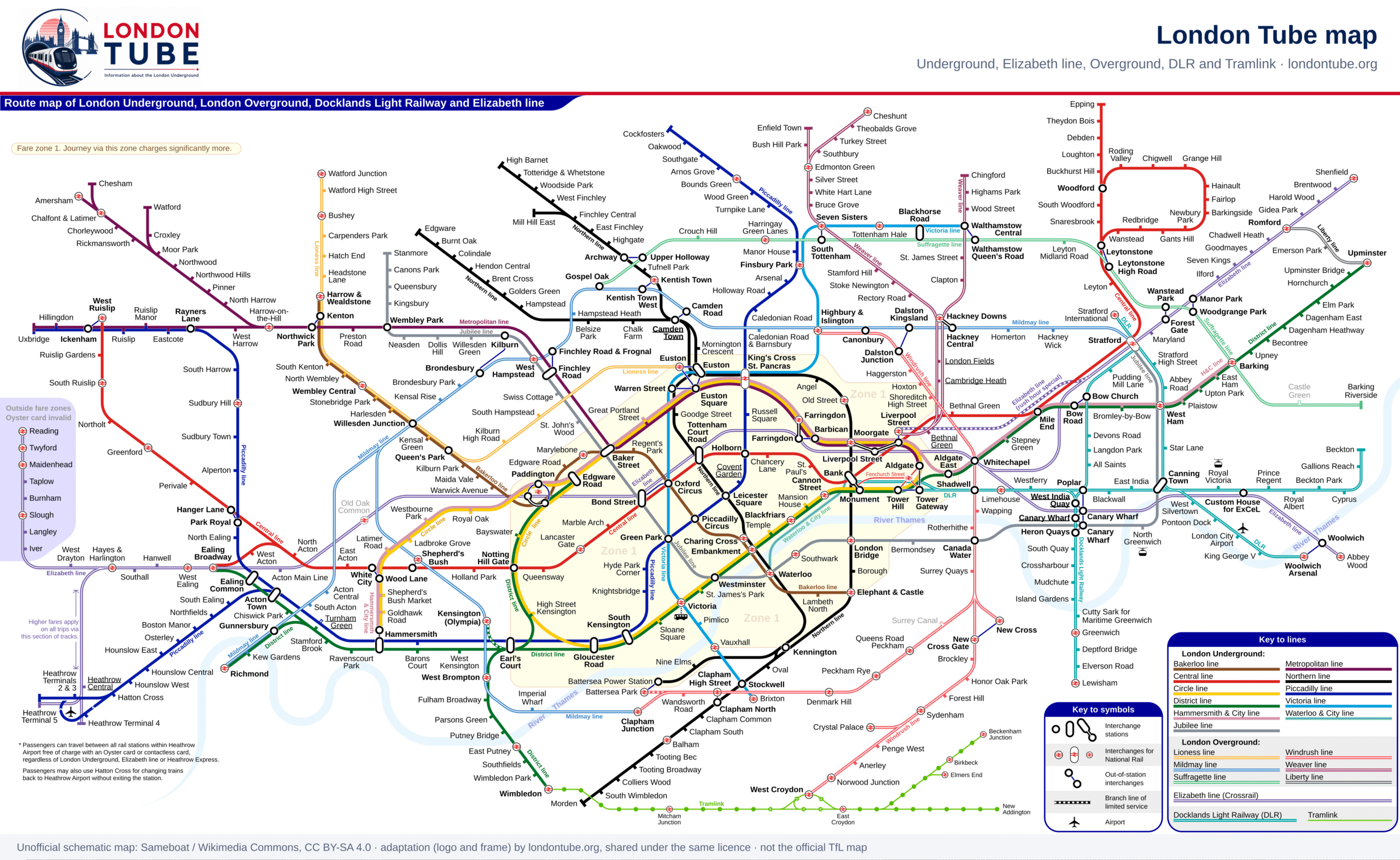
London Tube map
Every Underground line and station on one map, with the Elizabeth line, Overground, DLR and trams. Tap to enlarge or download the PDF.
London tube map PDF
London Tube map · PDF
Vector PDF, sharp at any zoom. Save it to your phone for when there is no signal underground.
How to read the map
Each tube line has its own colour, used on the map, on station signs and on this site. White circles mark interchange stations where you can change line; a station drawn as a tick on one side is served by that line only. The map is a diagram, not a street map: distances are not to scale, and two stations that look far apart can be a few minutes’ walk from each other.
The map also shows the Elizabeth line (purple double line), the six London Overground lines (Liberty, Lioness, Mildmay, Suffragette, Weaver and Windrush), the DLR in Docklands and Tramlink in south London. They all take Oyster and contactless, but they are not part of the Underground and are not covered on this site.
| Line | Stations | Main route |
|---|---|---|
| Bakerloo | 25 | Elephant & Castle – Harrow & Wealdstone |
| Central | 49 | West Ruislip – Epping |
| Circle | 36 | Hammersmith (Circle and H&C lines) – Edgware Road (Circle line) |
| District | 60 | Ealing Broadway – Upminster |
| Hammersmith & City | 29 | Hammersmith (Circle and H&C lines) – Barking |
| Jubilee | 27 | Stanmore – Stratford |
| Metropolitan | 34 | Amersham – Aldgate |
| Northern | 52 | Morden – High Barnet |
| Piccadilly | 53 | Uxbridge – Cockfosters |
| Victoria | 16 | Brixton – Walthamstow Central |
| Waterloo & City | 2 | Waterloo – Bank |
Fare zones on the map
Fares depend on the zones you travel through. Zone 1 is central London; zones 2 to 6 ring it, and the Metropolitan line runs out to zones 7, 8 and 9 in Hertfordshire and Buckinghamshire (Amersham and Chesham are in zone 9). Some stations sit on a boundary and count as either zone, whichever is cheaper for your journey. Each station page on this site gives its zone; fares are on Tube fares.